The Science Behind IWM
Protocol Development
IWMM completed an extensive pilot phase (2010-2015) for testing, revising, and improving waterbird and habitat monitoring protocols through feedback from monitoring participants. IWMM also created a National Protocol framework to guide use of the monitoring component by cooperators within the National Wildlife Refuge System (NWRS). This framework enables refuges to develop site-specific protocols that are compliant with recently updated NWRS inventory and monitoring policy. Following an intense peer-review process, a National Protocol Framework was approved by the Inventory and Monitoring Branch in January 2015.
Habitat Protocol Validation
In 2012, IWMM conducted a validation study focused on the performance of the pilot approach to rapid visual estimates of habitat features. Visual estimates were compared to assessments made via traditional vegetation quadrats and the classification of high resolution color-Infrared aerial images. Along with participant feedback, the 2012 study led to major changes in IWMM’s habitat sampling approach. Results of this study were published in 2016 and are available here.
A second validation study targeting the newly revised protocol was initiated in the summer of 2014. This assessment will compare the performance of the revised protocol’s seed production index against quantitative assessments for moist-soil plants. The study will also evaluate the performance of unit-scale habitat type cover and vegetation to water interspersion estimates against products derived from high resolution color-Infrared aerial images. The field data collection, quantitative seed estimates, and remote sensing captures are complete. However, this project is currently on hold due to resource limitations.
Wetland Management Planning and Decision Support

Figure 1. Two possible management action portfolios for freshwater impoundments at Mattamuskeet NWR. Each colored area represents a specific combination of hydroperiod and vegetation manipulation possible at each of the refuge’s 14 impoundments.
To assist managers at the local scale, IWMM has developed a model that helps managers coordinate habitat management actions across multiple managed units to benefit waterbirds while also considering costs and other constraints. The model uses a Structured Decision Making (SDM) framework to identify management alternatives, or “portfolios”, different collections of management actions that could be employed across impoundments (Figure 1). The benefits of individual portfolios are evaluated, and the collection of management actions that maximizes benefits to waterbirds with respect to constraints is identified.The wetland manager can then use this portfolio to guide and coordinate management actions, and use IWMM monitoring to evaluate response to management, update model parameter estimates and test alternative models.
This decision support for wetland management has been developed through pilot projects at two national wildlife refuges, Mattamuskeet NWR in NC and Clarence Cannon in MO. For both projects, final case study reports have been prepared. IWMM is currently exploring strategies for making this modeling approach more widely available.
Using Monitoring Data to Improve Inferences About Migration
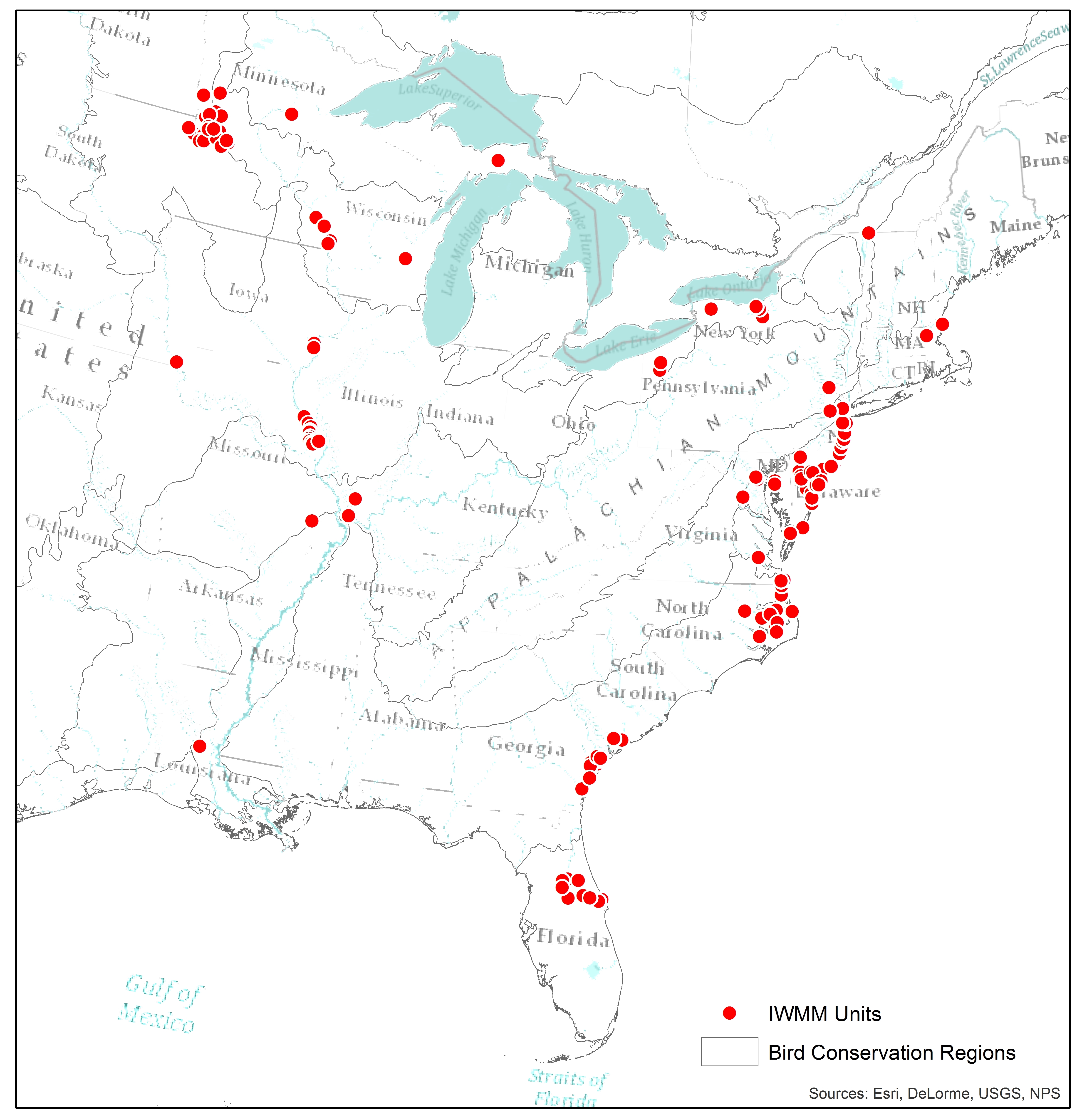
Figure 2. Distribution of IWMM sampling sites in the Mississippi and Atlantic flyways and across 15 BCRs.
IWMM is one of the few monitoring programs to collect the kind of large-scale, local level data necessary for drawing inferences about migratory patterns andprocesses (Figure 2). IWMM has quantitative scientists analyzing these data to elucidate the connection between habitat conditions and waterfowl abundance. These data identify landscape features to which migrating dabbling ducks respond, and can inform management decisions both locally and regionally (Summary or full publication).
The Migration Model
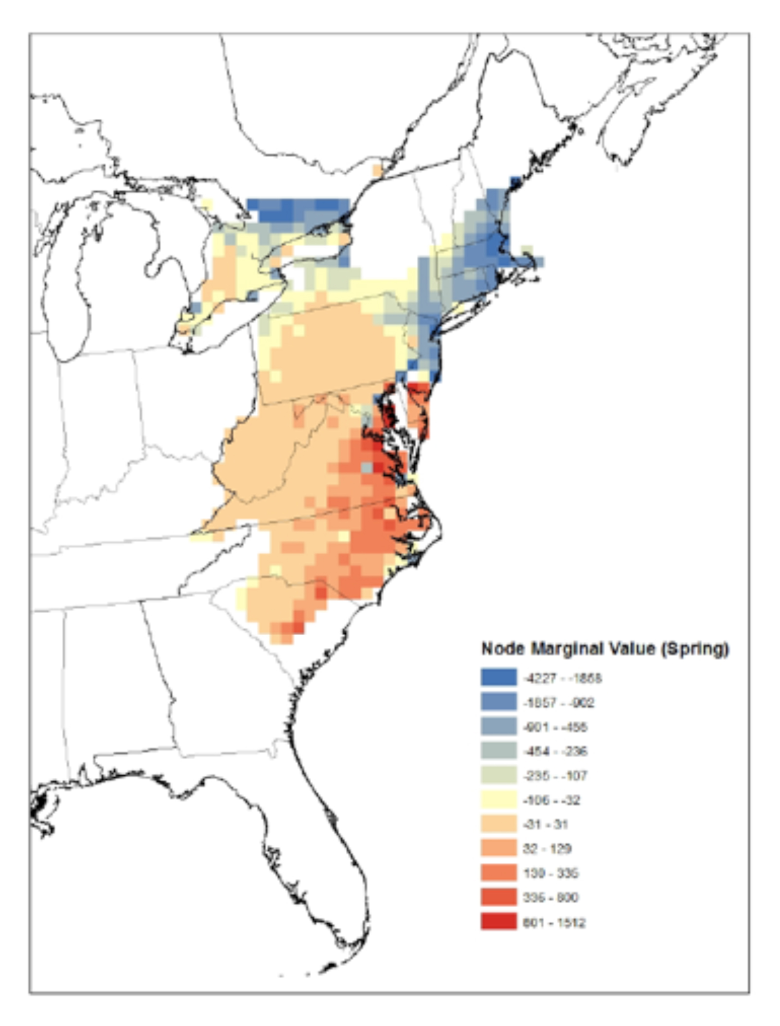
Figure 3. Marginal value analysis to determine importance of nodes for Atlantic flyway survivorship during the spring migration. Warmer colors show most essential locations for increasing survival.
IWMM has developed an ecological process model that simulates waterbird migration and links survival during this period to distribution of kilocalories available across the landscape. To “migrate” birds across the continent, the model incorporates GIS inputs (e.g., landcover, breeding and wintering range maps, population estimates, roosting quality, forage availability), and information from published studies of waterfowl behavior and natural history (e.g., food habits, flight speeds, travel distances).
The GIS layers are integrated to summarize quality of area at a node scale (nodes are 20×20 miles in size). The model produces a map of kcals available for each species for which it is run, then simulates bird movement through the flyway based on parameters from the literature. The model is currently parameterized for mallards but could be adapted to model migration in other waterfowl, shorebirds and waders. Model output can inform flyway scale management decisions by identifying areas on the landscape that should be prioritized for conservation because of their influence on migratory success. For example, removing energy one “node” at a time from the Atlantic Flyway suggested coastal areas between New Jersey and North Carolina, including Chesapeake Bay and the North Carolina piedmont, are essential locations for efficient migration and increasing survivorship during spring migration (Figure 3).
For the regional scale, the migration model can be used to identify which set of sites is most important for each waterbird guild. For the local scale, it identifies which guild a site should focus management on, given the site’s placement within the flyway.
To evaluate how well the model replicates empirical distribution patterns of waterbirds and the frequency and distance of typical migration movements, the IWMM Technical Team conducted model validation tests. The validation exercise indicated good agreement between bird-use days as estimated by the migration model and those calculated from eBird data for Mallards, based on more than 1,000 areas where this comparison could be made. The model has been peer-reviewed and a paper describing the modeling process and validation was published in 2016. A summary of that paper can be viewed here. Plans are now underway to apply the model to evaluate the importance of National Wildlife Refuge lands to migrating waterfowl.